Earthquakes & Volcanoes


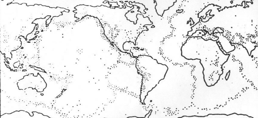
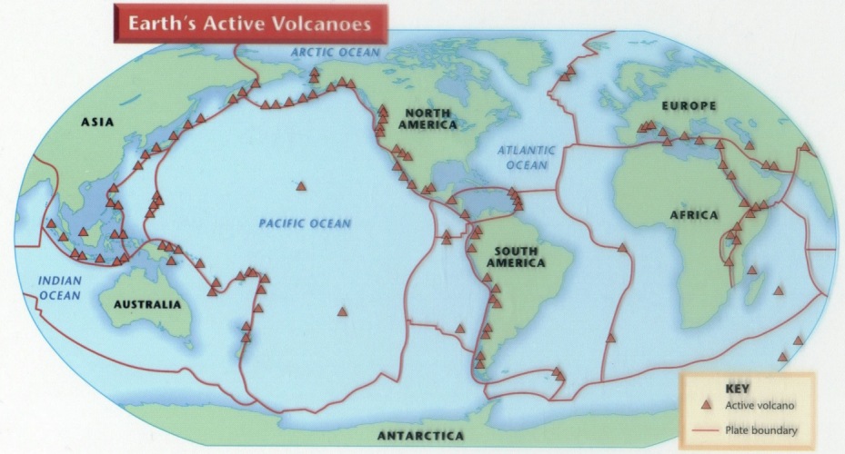
Earthquakes, volcanoes and mountain ranges tend to happen in similar areas.


The map above shows frequent earthquake activity as the bands of dots.


Most of the world's active volcanoes (triangles) are along the edges of tectonic plates (the lines).

Types of Plate Boundaries

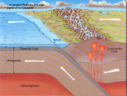
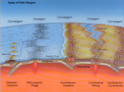
Convergent- plates collide into each other.

Where an oceanic and a continental plate collide, the denser oceanic plate will be forced under (subduction) the other.

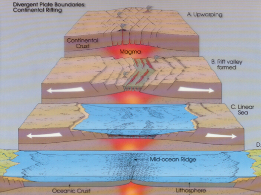
Divergent

  • plates spread apart
  • caused by magma upwelling from deep in the Earth
  • usually found in the oceans along with mid-ocean ridges


Speed Links

Continental Drift

Seismic Waves

Time Math

P & S Wave Chart

EQ Strength

EQ Waves as X-Rays

Worksheets
&
Downloads


Vocabulary

Coordinates practice

Seismic Eruption*

Time Math 1

Time Math 2

When 2 Cars Race (P & S Race PPT for answers)

Determining Epictr Distance

Finding Epicenters I

Finding Epicenters 2

Epicenters 3

Epicenters 4

Seismic Waves*

Calculating Richter Scale


* Seismic Waves and Seismic Eruption are free demonstration programs available at: binghamton.edu


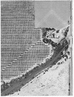
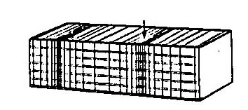
Transform- two plates slide past each other.


In this aerial view of the San Andreas Fault (transform) the trees in the orchard (dots) have been offset by the slipping of the plates. The Pacific Plate is to the left and the North American to the right.


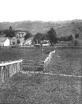
This picture shows how things like fences, roads, rivers and buildings can be offset by the sliding of the plates.

The exception to this arrangement are "Hot Spots" which are plumes of hot material (rather than belts) in the middle of plates. These spots stay stationary while the plate moves above it. The spot melts through the plate like a blow torch and produces a volcano above it. As the plate moves, the spot melts through another spot producing a chain of volcanic islands. Hawaii is an example of a hot spot island chain.

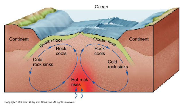
The movement of the plates is caused by convection currents deep within the Earth. The force that moves the plates around the earth are convection currents inside the mantle.

  • Hotter Mantle material rises while cooler material sinks.
  • The crust is split and diverges where the material rises and spreads out.
  • The plates converge and subduct where the material is sinking.

The different types of plate boundaries are caused by a combination of the direction of convection as well as they type of crust: continental or oceanic.

Back to Top

Evidence of Continental Drift

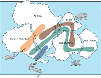
  • Puzzle Fit of the continents to form Pangaea (see below)
  • Fossil Evidence (see below)
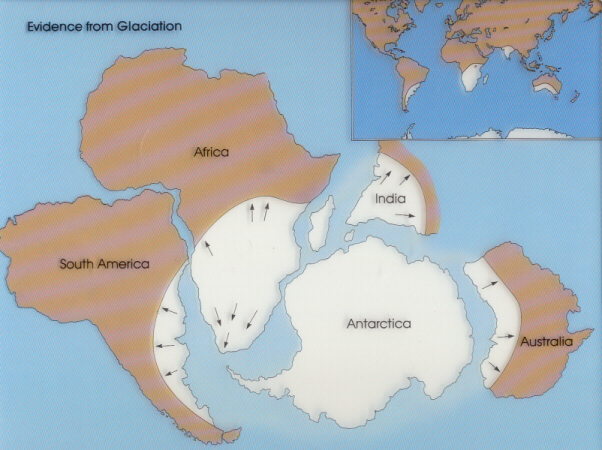
  • Glacial Evidence (see below)
  • Coal in Antarctica- coal is formed in tropical swamps. Coal was formed when Antarctica was closer to the equator.
  • Magnetic Stripes on the ocean floor (this one's going to take some explaining so it gets its own page)
  • Mountain Chains appear where they should if continents are colliding

Puzzle Fit- if the continents were cut out of a map, most of the landmasses will fit together to form a larger supercontinent, which is called Pangaea.

Fossil Evidence- in the picture above, fossils of many land-living have been found on opposite shores. When Pangaea is re-assembled, the fossils match up.

Glacial Evidence- when Pangaea is re-assembled, there is evidence of a single ice sheet (at least for this episode) affecting many of the southern continents. When viewed this way, this sheet leaves consistent evidence of a single glacier. When viewed on the current continents, it is inconsistent and even highly improbable. For example, India, which is north or the Equator, has glacial evidence coming from the south!

Back to Top

Earthquakes

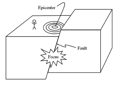
An earthquake is an event where two pieces of crust shift against each other. The rumbling felt is from the rocks slipping, sticking and breaking. The vibrations are called seismic waves. There are different types of seismic waves that vibrate in different ways.

The focus is the spot within the earth where the earthquake began.

The epicenter is the spot on Earth's surface closest to the focus.

A fault is a crack along which the rocks slide.

Seismic Waves- during an earthquake, several types of waves are generated. The vibrations felt are actually called seismic waves that are traveling through the Earth.

P-Waves

  • Primary wave- travels phastest so it arrives at seismic stations phirst.
  • Push-pull wave: rock vibrates forward and backward in the same direction that the wave travels ("parallel to propagation").
  • Pass through solids and liquids (magma).

S-Waves

  • Secondary wave- arrives at a seismic station second.
  • Slow wave- not as fast as the P-wave.
  • Shake wave (shear wave)- vibrates side-to-side.
  • Solids wave- only travels through solids.

Youtube Video demonstrating P-Waves and S-Waves.


Back to Top

Time Math


In order to do the calculations that help find the distance to epicenter and the time of the earthquake, you’ll need to do math with time. It is difficult to do time math in a calculator, and by hand it does not work exactly the same way as regular math. Regular math is what they call “base 10” which means that whenever you count past 9 you must move over one place to the tens column. Time is base 60. You can count 59 seconds and then you go to the minutes column.
For example, if you want to subtract 82 minus 17 in regular base ten numbers you would “borrow” a ten and start by taking 7 away from 12.

82
-17

is the same as
8712 (70 plus 12)
-17
65

Time math works almost the same way except instead of taking over ten from the neighboring column you’ll take one minute and convert it into 60 seconds.
3:13:25 (“3 hours, 13 minutes, and 25 seconds”)
-1:09:37
turns into:
3:12:85 (3 hrs,12 min, 85 secs is the same as 13:25)
-1:09:37
2:03:48

How to Use the P-Wave and S-Wave Travel Time Chart

P-Wave & S-Wave Chart (opens a new window so your pop-up blocker may stop it)

The P-line shows how much time it take a P-wave to travel a certain distance. So if you need to know how much time it takes the p-wave to travel 2,000km, it is just over 4 minutes (about 4:05 ). The S-wave works the same way: for 2,000km it takes 7:20 .

To find the distance to epicenter:

You are in charge of watching the seismic station tonight when the seismograph detects an earthquake. The earthquake didn’t happen where you are- you can’t even feel it. As a result, you don’t know what distance or direction the earthquake happened. The P-wave and S-wave are separated by 4:05 (4 minutes, 5 seconds). You need to find a spot on the graph where the P-line and the S-line are separated by 4:05 .

  • Take a scrap piece of paper, line it up along the left edge of the chart.
  • Put a small tick mark on your scrap paper at zero, and a small tick mark at 4:05 .
  • Slide the scrap paper up along the chart until it the two tick marks just touch the P and S lines. BE SURE THAT YOUR SCRAP PAPER IS PERFECTLY STRAIGHT UP AND DOWN (use the lines on the grid as a guide).
  • Now that you have found the right spot on the graph, drop a line straight down to the bottom of the graph to read the distance- 2,600km.

To Find The Time That The Earthquake Occurred

When a seismograph detects an earthquake that happened at some distance, (2,600km for example) you know that the earthquake happened some time in the past and it took time for the waves to reach your station. But how long ago? All you need to do is answer the question “how long does it take a P-wave to travel 2,600km?

  • Find 2,600km on the bottom of the chart.
  • Go straight up until you reach the P-line and read the time from the left of the chart: 5:00 (5 minutes).
  • Now compare times: if you detected the earthquake at 3:17:00 and it took 5:00 then the earthquake happened 5 minutes before 3:17:00 or 3:12:00 .

Back to Top

Earthquake Strength

The intensity or strength of an earthquake is measured in two main ways:

  • The Richter Scale
    • measures the amount of energy that an earthquake releases
    • Each number of magnitude is 10x stronger than the number below it.
  • The Mercalli Scale
    • Measures the amount of damage from an earthquake
    • Ranges from I to XII
    • Based on common earthquake occurrences such as "noticeable by people" "damage to buildings" chimneys collapse" "fissures open in the ground”.

Seismic waves as “x-rays”

  • P-Waves travel through solid and liquid
  • S-Waves travel only through solids
  • Seismic waves travel faster through denser material.
  • Because of this, the path traveled by a seismic wave is bent towards the surface.

Shadow Zone diagram photoshop drawing by Phil Medina

Properties of the material (such as density and pressure) that the waves pass through can be inferred by the speed and angle that the waves travel.
The layers of the earth are determined by the jumps in velocity and “echoes” of seismic waves.

The MOHO is a boundary between the crust and the upper mantle where the velocity of waves jumps up sharply. This sharp increase in velocity is called a discontinuity.


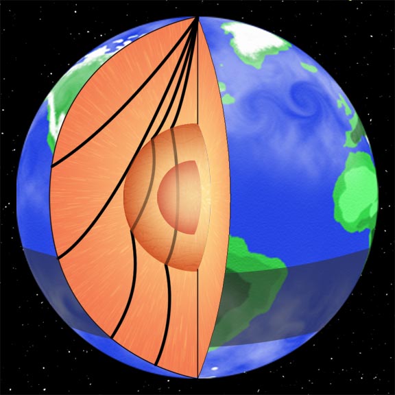
A shadow zone occurs on the opposite side of the earth from an earthquake because of the liquid outer core. S-Waves are stopped all together while the P-Waves are refracted (bent) to create a zone where no waves are picked up at all. This zone is between 102° and 143°around the earth from the earthquake.

Lab research and studies of meteorites suggest that the core is made of Iron and Nickel (FeNi).

Back to Top


Over 15 years of
Medina On-Line
1994-2011